CertiflAI
Increase the efficiency of your aerial image inspection
What is CertiflAI?
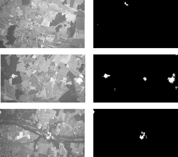
This is a desktop application designed to inspect aerial photographs for defects. It detects blurring, clouds, cloud shadows, smoke and radiometric errors (discoloration, overexposure and flashes). Then, on this basis, the person inspecting the images can quickly pinpoint an area that requires aerial photography to be redone – especially as the data to be verified is increasing year on year.
Main target group
CertiflAI has been developed for the needs of state organizations dealing with strategic aspects of land management in a country. Their responsibility is to ensure the quality of the aerial photographs they receive. In addition to this, it can be successfully used by private entities that process raw aerial photographs.
What differentiate us?
Existing methods used to inspect aerial photographs become ineffective when used for different types of images, i.e., vertical, oblique, as well as towards products requiring a higher density of raids, e.g., for True Ortho or 3D MESH.
In view of this, we used deep learning and machine learning mechanisms, feeding the application with tens of thousands of images from our own repository in order to teach the application to detect selected types of defects in aerial photographs with their specificity in mind.
The application is continuously improved and we can develop the software to detect other defects on request. As a result, the client has a real influence on the development of the software.
Technology used
CertiflAI uses convolutional neural networks to perform inspection of aerial photos. They are trained on large data sets with simulated defect. These data are from different aerial seasons, years, terrains and are of different resolutions.
To detect a defect in an aerial photo, the user selects the type of defect to be detected and the folder containing the datasets requiring inspection, as well as other auxiliary parameters such as defect size thresholds (for cloud incidence analysis, among others). Each image is then imported in the appropriate form into the neural network and a defect probability score is generated. If a defect is detected, a result is generated based on it, compiled in a format according to the customer’s requirements (e.g., a report) to more easily identify photos with a defect along with marking its location on the photo for certain types of defects.
The advantage of CeriflAI is the short time for analyzing the occurrence of a defect in images. Thanks to the technology used, it takes about a dozen seconds to detect, for example, blurriness alone for one aerial photo, while the detection of all defects is about 40 seconds per photo.
Traditional inspection is not as accurate, and takes much longer.
Functionality
The application is easy and intuitive for anyone to use after only a few minutes of training.
Both a single image and an entire collection of aerial photographs can be analyzed, and it is possible to set the sensitivity to which the programmed should interpret an object as a defect.
It is also possible to extract metadata from the structure of the folder containing the images.
CertiflAI uses different solutions in its work depending on the type of defect:
For the detection of clouds, cloud shadows, smoke, blurring, discoloration and flares, deep learning models are used.
For the detection of overexposure, traditional algorithms are used.
Depending on the needs, it is possible to indicate in which direction the search for defects is to be performed, limiting itself to clouds and cloud shadows, for example.
The analysis results are easy to interpret due to the indicated area where the defect is located.

Benefits from implementation
Huge savings in working time. On average, 98% of the aerial photographs delivered to a client are taken correctly. The checker therefore spends almost all his working time checking images that are qualitatively correct.
Faster decision-making on whether defects are relevant to the quality of the resulting images
A shorter period of time between placing an order for aerial photographs and obtaining all the correct images.
Other products
For a more complete demonstration of our activities, we encourage you to take a look at our other products:
See also – 360° Perspective
A suite of services and products related to spatial data acquisition from any ceiling.

OPEGIEKA Sp. z o.o.
Aleja Tysiąclecia 11 82-300 Elbląg
tel. +48 (55) 237 60 00
fax +48 (55) 237 60 01
Facility in Warsaw
ul. Grzybowska 80/82 lok.
700 00-844 Warszawa
