SimplyGEO
2D and 3D data viewer
What is SimplyGEO?
It’s a browser-accessible application for viewing and working on aerial data, especially vertical and oblique images. It also allows presentation of products such as orthophotos, True Ortho, 3D models, point clouds and others. A number of advanced tools are implemented to work on 2D and 3D data.

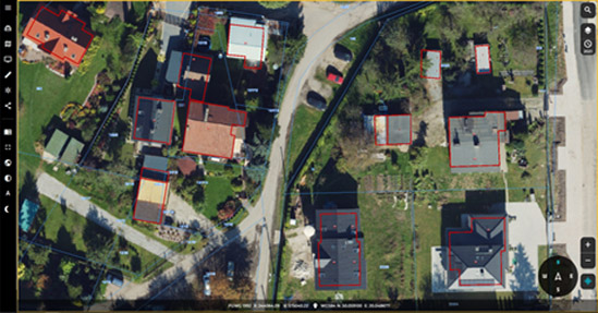
TrueOrtho with an applied layer of parcels and buildings derived from the EGiB
Main target group
SimplyGeo is a viewer dedicated to institutions or companies that use aerial data internally and for public use. SimplyGeo is created to display and analyze spatial data – aerial or own vector layers. Each user has the ability to fully exploit the potential of their own spatial data. The interface is designed to be intuitive and allow users who have had no previous experience with GIS applications to perform everyday tasks without any problems.
What differentiate us?
In response to customer demand, we designed an intuitive tool that is capable of handling many types of spatial data in the same way.
The screen interface is divided into a main section that displays the selected data layer and a toolbar on the left side. Depending on the user’s selection, contextual tools may also be displayed. The use of commonly understood symbols along with the clear highlighting of the selected icons is also beneficial to the ease of working with the browser. In addition, the system displays text information with the name of the currently indicated tool. Toolbar elements have been grouped thematically, making it easier to find the desired functions.
Map navigation is intuitive and allows for zooming in and out of perspectives as well as smooth transitions between changes in the areas being analyzed.

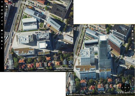
View of SimplyGeo application with split-screen work TrueOrtho on the left and oblique images on the right with change of direction)
Technology used
SimplyGeo can be deployed on the customer’s infrastructure or at OPEGIEKA’s Data Center in a SaaS (Software-as-a-Service) model.
The technology used is compatible with all aerial, mobile and satellite imagery processing products.
Supported map modes include orthomosaics, oblique mosaics, oblique orthoimagery, 3D reality model and point cloud, among others.
Functionality
A tutorial to speed up getting started with the system.
Easy-to-use interface.
Ability to load layers and take simple measurements.
Perform spatial analysis, e.g., shading simulations on a 3D reality model.
Quick search by object, address point or street.
Ease of feeding the application with spatial data.
Full access to historical data (if available).
Implementation benefits
Ability to integrate the viewer with other systems and data.
Access to all spatial data in one place.
Ability to run on any device.
Wide possibilities for analysis of spatial relationships due to interference of many data in one place.
Ability to measure any mapped element on vertical, oblique image or 3D models.
More about 360° perspective
SimplyGeo is one of the products from bundle 360° Perspective. You can read more about other products from 360° Perspective here:
Other products
For a more complete demonstration of our activities, we encourage you to take a look at our other products:

OPEGIEKA Sp. z o.o.
Aleja Tysiąclecia 11 82-300 Elbląg
tel. +48 (55) 237 60 00
fax +48 (55) 237 60 01
Facility in Warsaw
ul. Grzybowska 80/82 lok.
700 00-844 Warszawa
